
Cyclone Ditwah Leaves Trail of Catastrophe in Sri Lanka Before Moving Northward
Colombo, Sri Lanka – November 28, 2025
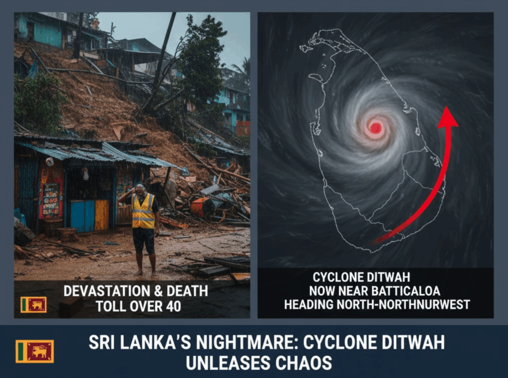
Sri Lanka is reeling from the devastating impact of Cyclonic Storm ‘Ditwah’, which intensified rapidly in the Bay of Bengal and has cut a swathe of destruction across the island nation. As of Friday morning, the powerful storm system, which made landfall on the eastern coast, is now centered approximately 60km south of Batticaloa and is continuing its movement, bringing perilous weather conditions to the country and setting a worrying trajectory toward the Indian coast.
The Department of Meteorology has confirmed that the system is currently positioned close to Pottuvil, near Sri Lanka’s southeastern coast, and is tracking north-northwestwards. This movement threatens further downpours across the central and western provinces before the cyclone is expected to emerge into the open sea off the North Tamil Nadu, Puducherry, and South Andhra Pradesh coasts by early November 30.
The Meteorological Department has issued an urgent public advisory, requesting all residents to remain vigilant and take necessary precautions as the slow-moving storm continues to influence weather patterns across the island.
The Genesis and Trajectory of Ditwah
Cyclone Ditwah, named by Yemen as per the regional roster, began its life as a well-marked low-pressure area over the southwest Bay of Bengal around November 26, 2025. Fueled by favourable atmospheric and oceanic conditions, the system rapidly intensified:
- November 26: Formed as a depression just offshore the southeastern coast of Sri Lanka.
- November 27 (Early Morning): Intensified into a Deep Depression.
- November 27 (Afternoon): Strengthened further into a Cyclonic Storm, earning the name ‘Ditwah’ (often spelled ‘Ditwa’ in Indian reports). It was located near latitude $6.9^\circ \text{N}$ and longitude $81.9^\circ \text{E}$, close to Pottuvil, approximately $90 \text{ km}$ south-southeast of Batticaloa.
- Predicted Trajectory: The India Meteorological Department (IMD) forecasts the cyclone will continue its north-northwestwards movement, tracking across the waters adjoining the Sri Lankan coast before making its decisive push towards the North Tamil Nadu, Puducherry, and adjoining South Andhra Pradesh coasts by the end of the month. Peak wind speeds were initially predicted to be in the range of $80\text{–}90 \text{ km/h}$, with gusts up to $100 \text{ km/h}$, suggesting a significant impact as it skirts the Sri Lankan coastline.
A Catastrophic Human and Infrastructure Toll
The passage of Cyclone Ditwah has inflicted severe and widespread damage across Sri Lanka, turning the weather event into a major national catastrophe. Initial reports from the Disaster Management Centre (DMC) confirm a rising human toll, which is expected to climb as rescue efforts reach isolated areas.
Key Damage and Fatality Figures (as of November 27):
| Area of Impact | Confirmed Fatalities | Missing Persons | Severity of Damage |
| National Total | Over 40 | 21+ | Widespread flooding, deadly landslides, and destruction. |
| Badulla District | 23 | – | Worst-hit area for landslides, high displacement. |
| Kandy District | 5 | 20 (after Gangoda landslide) | State of emergency declared; 37 homes destroyed. |
| Nuwara Eliya | 6 | 4 | Severe impact on highland communities. |
| Ampara | 3 (swept away by floods) | – | High impact from coastal flooding. |
The death toll, now tragically exceeding 40 people, includes five fishermen, highlighting the peril faced by coastal communities despite warnings. The Badulla district, a historically vulnerable area in the central highlands, has been the hardest hit, accounting for the largest share of fatalities due to devastating landslides.
In the Kandy District, a state of emergency was declared, with over 3,500 people affected and a single landslide in the village of Gangoda reportedly leaving 20 people missing, an incident compounding the already declared five fatalities in the region.
Infrastructure and Economic Paralysis
The ferocious winds and relentless rainfall have caused massive infrastructural paralysis across the island:
- Widespread Flooding: Continued rainfall over the mountainous central regions is predicted to trigger massive downstream floods, threatening Western and Southern lowlands, including the densely populated regions of Ratnapura, Galle, Matara, and even parts of the commercial capital, Colombo.
- Transportation Blackout: Railway services in the mountainous region have been suspended or disrupted as mud, rocks, and trees have fallen onto tracks, with some sections completely inundated. Major roads connecting provinces are closed, isolating communities and severely hampering relief and rescue efforts.
- Reservoir Crisis: Rivers and reservoirs across the country are swelling to dangerous levels, increasing the threat of catastrophic overflow and further inundating adjacent villages.
The trajectory of Ditwah, cutting across central highlands including Badulla and Nuwara Eliya before moving toward Kurunegala and Anuradhapura, threatens regions that are vital for the country’s agriculture and transportation network, adding a significant economic dimension to the disaster.
As the system moves away from the immediate Sri Lankan coast towards South India, the immediate threat of heavy rainfall and associated flooding persists over the island for at least the next 24 hours. Disaster management teams and military units remain on high alert, working to evacuate high-risk zones and coordinate aid to the thousands of displaced families across the ten most severely affected districts.


