
Brace for Impact: Severe Weather Batters South Island’s West and Tasman Coasts
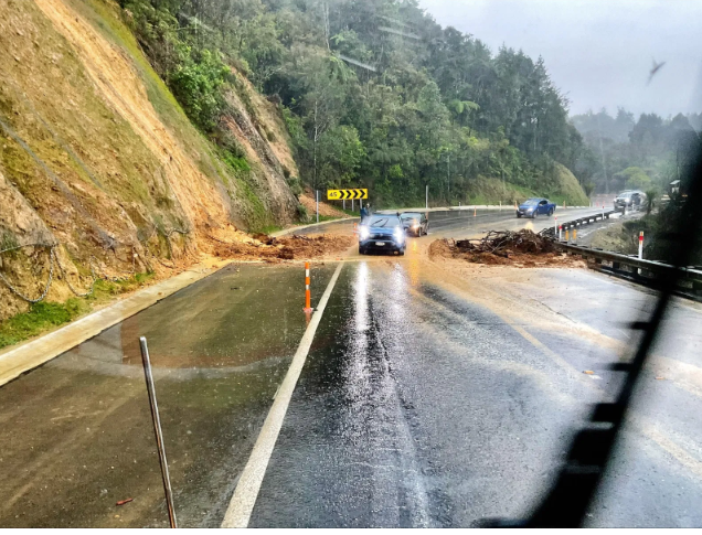
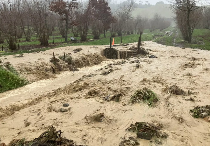
WELLINGTON, NZ – New Zealand’s MetService has issued a severe weather warning for much of the Tasman and West Coast regions of the South Island, effective from midday today, Tuesday, July 29, 2025. Residents are being urged to prepare for a significant period of heavy rain, potentially reaching warning levels, coupled with strong to severe northwesterly gales. The adverse conditions are expected to bring a heightened risk of localized flooding, landslips, and considerable disruption to travel, prompting emergency services to advise heightened vigilance.
The incoming weather system, characterized by its intensity and widespread nature, is a typical winter frontal passage impacting the western flanks of the South Island. Forecasts indicate that accumulated rainfall could exceed 100-150mm in higher elevations and up to 60-80mm at lower altitudes within a 24-hour period. Such volumes are sufficient to swell rivers and streams rapidly, raising the potential for surface flooding in low-lying areas and posing a significant threat of slips on vulnerable hillsides.
Beyond the rainfall, severe gale-force winds are anticipated to lash exposed coastal areas and higher ground, with gusts possibly reaching 120 km/h. These strong winds could cause damage to trees, power lines, and unsecured structures, making driving conditions particularly hazardous for high-sided vehicles and motorcycles. Motorists traveling through the region, especially along key routes such as State Highway 6, are advised to exercise extreme caution and consider delaying non-essential journeys.
Local councils and emergency management teams in Tasman and on the West Coast have activated their response protocols, monitoring river levels and road conditions closely. Residents in areas prone to flooding or slips are encouraged to secure loose outdoor items, clear drains, and have emergency kits prepared. Updates on road closures and changing conditions will be disseminated through local media and official channels, underscoring the importance of staying informed.
As the weather front continues to move across the country, other regions, particularly those in the central North Island, may also experience some spill-over effects. However, the primary focus remains on the South Island’s western regions, where the combination of intense rain and strong winds could create challenging and potentially dangerous conditions. The MetService urges everyone in the affected areas to heed the warnings, prioritize safety, and be prepared for potential disruptions over the next 24 to 48 hours.


