
Climate Chaos: Heavy Rain, Gales, and Summer Snow Forecast for South Island
By Lions Roar Aotearoa Weather Desk
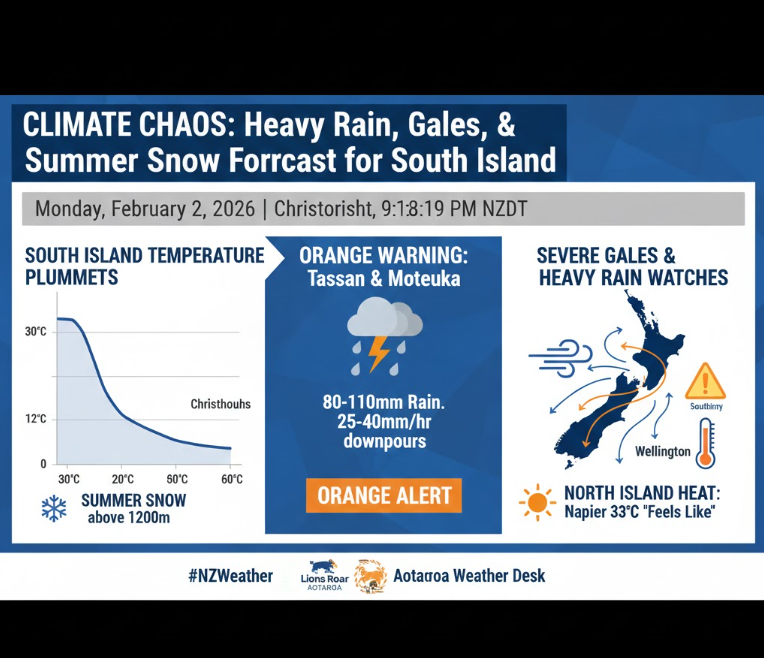
CHRISTCHURCH, NEW ZEALAND (Monday, February 2, 2026) — New Zealand is witnessing a dramatic climatic divide this week as a powerful southerly front prepares to lash the South Island with heavy rain, severe gales, and unseasonable snow. While the North Island swelters under extreme heat alerts, residents in the south are being urged to swap sandals for gumboots as temperatures are set to plummet.
MetService has issued a series of warnings and watches, with the most severe conditions expected to hit the Tasman District and the Canterbury region overnight and throughout Tuesday.
🟠 Orange Warning: Tasman & Motueka
An Orange Heavy Rain Warning is in effect for the Tasman District, northwest of Motueka, starting at 4:00 AM Tuesday.
- Expected Rainfall: 80mm to 110mm, particularly in the ranges.
- Peak Intensity: Downpours of 25mm to 40mm per hour are likely on Tuesday morning.
- Risk Factor: Possible thunderstorms; MetService notes a minimal chance this could be upgraded to a Red Warning if conditions intensify.
📉 The Christchurch Cold Snap
In one of the most drastic shifts of the season, Christchurch will swing from a near 30°C day on Monday to a “fairly chill” Tuesday. MetService predicts the city’s maximum temperature of 15°C will occur well before dawn on Tuesday, with southerly winds dropping the mercury to just 12°C for the remainder of the day.
- Heavy Rain Watch: In place for Christchurch and Canterbury north of the Rangitata River from 2:00 AM to 10:00 PM Tuesday.
- Summer Snow: In an unusual twist for February, precipitation is expected to fall as snow above 1,200 metres in Canterbury during Tuesday afternoon and evening.
🌬️ Wind Watches & North Island Heat
The weather system is also bringing significant wind risks to central New Zealand.
- Strong Wind Watch: Wellington and Eastern Marlborough (including the Sounds) are under watch from 7:00 PM Tuesday. Southerly winds may approach severe gale strength in exposed areas.
- West Coast Winds: The Westland and Grey districts are also under a strong wind watch from early Tuesday morning.
Meanwhile, the North Island remains in the grip of summer. Napier recorded a “feels like” temperature of 33°C today, triggering heat alerts. The contrast highlights the volatile nature of the current weather pattern as the cold front moves north.


