
Shrinking Sri Lanka: Coastal Erosion Swallows 1 Square Kilometre Every Five Years
By Lions Roar News Science & Environment Desk
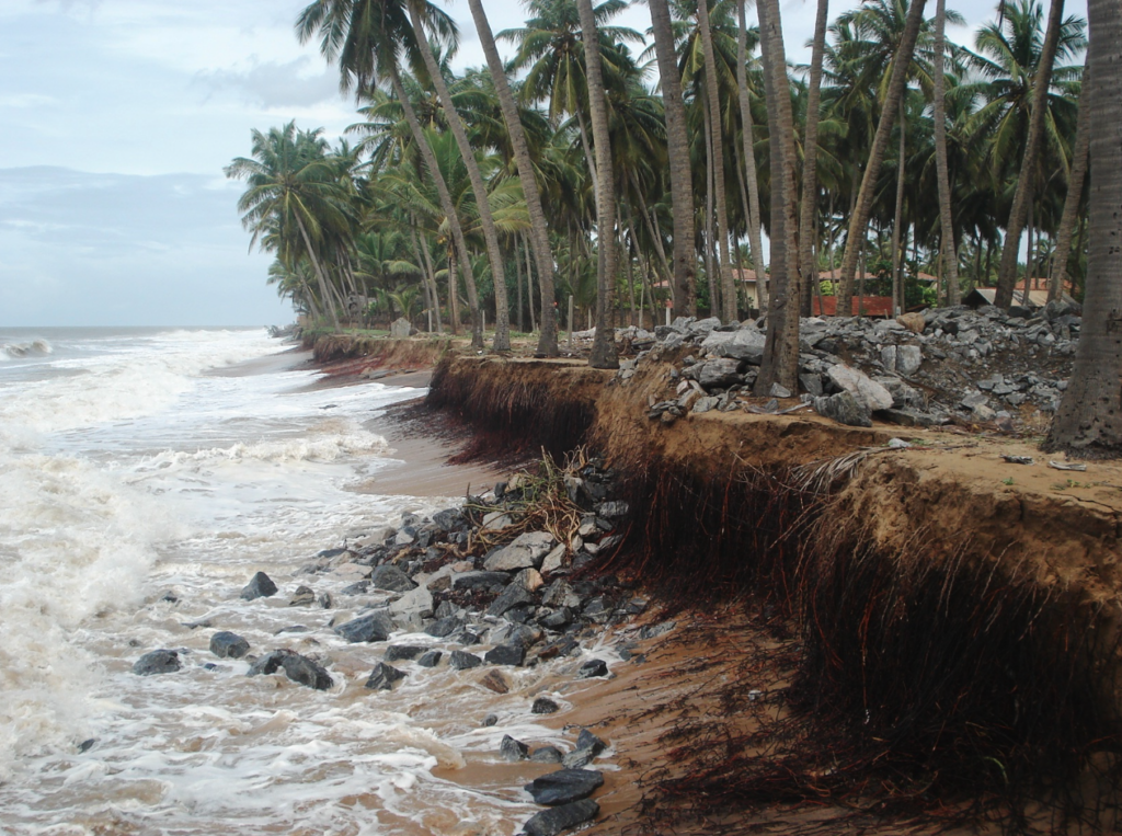
COLOMBO, SRI LANKA (Wednesday, January 14, 2026) — Sri Lanka is literally getting “thinner.” Expert geological data and recent environmental reports warn that the island nation is losing approximately one square kilometre of land every five to six years due to relentless coastal erosion.
While landslides and floods change the internal landscape, sea erosion is the only force permanently reducing the country’s total landmass, which currently stands at 65,610 square kilometres.
🌊 The Mechanics of Disappearance
Sri Lanka’s geography makes it a prime target for the Indian Ocean’s forces. Unlike colder regions, the tropical waters surrounding the island never freeze, meaning the coastline is under constant bombardment by waves and currents.
Key Drivers of Erosion:
- The “Monsoon Attack”: The Northeast Monsoon erodes the east, while the Southwest Monsoon batters the southern and western coasts for months at a time.
- Tidal Cycles: Daily high and low tides, along with the warm Equatorial Current, act as a “slow saw” cutting into the shoreline.
- Sea Level Rise: Research shows Sri Lanka’s sea level is rising at a rate of 3.5mm per year—a pace accelerated by global warming and melting polar glaciers.
📍 The “Danger Zones”
The Western, Southwestern, and Southern coasts are the most severely impacted. Residents and commuters can already see the effects:
- Railways at Risk: In areas like Dehiwala, Mount Lavinia, and Moratuwa, the ocean has crept up nearly to the railway tracks.
- Infrastructure Threats: In Induruwa and Beruwala, main coastal roads are frequently threatened by waves. Even protective walls are proving insufficient against the rising tide.
- The Most Vulnerable: The stretch between the Maha Oya river and Lansigama (near Negombo) is experiencing some of the most intense erosion, losing up to 12 metres of beach per year.
🛑 A Man-Made Crisis?
The erosion isn’t just a natural disaster; human activity in inland rivers is making it worse.
- The Sand Shortage: Rivers like the Mahaweli and Kelani traditionally carry sand to the coast to replenish beaches. However, large dams and excessive gem mining have trapped this sand inland.
- Sinking Riverbeds: In the Sitawaka River, gem mining has caused the riverbed to drop by nearly 20 feet, causing salt water to flow inland (salinity intrusion) and ruining drinking water supplies for Colombo.
- Lost Protection: Only 1% of Sri Lanka’s coast is protected by mangroves. Unlike nations like Cuba, which use mangroves as a natural shield, Sri Lanka has seen its mangrove systems decimated by shrimp farming and tourism development.
📊 The Data Gap
A significant concern raised today is the lack of precise measurement. Despite the existence of the Department of Coast Conservation and Coastal Resource Management, the exact square-meter loss across the 1,680km coastline is not yet fully calculated.
Experts call for a 100-year forecast and policy to move beyond temporary “sea walls” and toward a sustainable national strategy to save the island’s borders.


